By Bob Seidenberg
Some longtime residents living east of Ridge Avenue in Evanston’s Fifth Ward brought concerns about that area’s exclusion from the attendance boundaries of School District 65’s new school into a discussion of new political boundaries for the city.
At the city’s Redistricting Committee meeting Jan. 26, longtime resident Jane Evans told committee members the school district’s boundaries, which exclude the east side of the ward, made her question priorities for the east side of the ward versus the west, where the school will be located.
“We have lived in Evanston for 45 years, and I’ve lived on Gaffield for 34 and I come here with a really heavy heart actually,” Evans told Committee members. “I think that in the times that we have lived on Gaffield, I have, and my family has been incredibly supportive of every mission that the Fifth Ward Alderman has to deal with.
“And we were proponents of the Fifth Ward school and we are thrilled that it’s happening.”
But she said when “we realized that the boundary was Green Bay Road, it made me start to question how difficult it has been for the Fifth Ward alderman…to deal with priorities that are in the west side of the Fifth Ward, and what we deem as priorities on the east side of the Fifth Ward.” Problems, she said, “I know in so many ways are so much less important than what people on the west side of the Fifth Ward are dealing with.”
“And, so, I come here thinking that, as you look these boundaries, you might want to consider the geographic boundaries,” she told members of the Redistricting Committee. “I think it’s really hard to look at the various problems that we each have.”
Later in the meeting, Jim Swanson, a longtime resident of the Fireman’s Park area, at Simpson St., and Maple Ave., raised similar concerns about the exclusion on residents in that area, also east of Ridge.
“We lost Noyes School in the ’70s, and we do not have a walking distance to our school,” he told committee members. “It is 1.6 miles to Dewey [School] and .6 miles to the new school.”
Bobby Burns, the current Council member representing the ward, stressed at the start of the meeting and also during later discussion, that ward boundaries are separate from school boundaries.
“It’s not a unified city like Chicago is,” he pointed out. “They [District 65] went through their own process, deciding where the boundaries will be.”
He urged residents to attend the meetings the District is planning to hold next month on the school-boundary issue.
“And I’m only saying that because I really, really want the District to hear you on that,” he said.
The first such event is scheduled from 10 a.m., to 11:30 a.m. Feb. 4 at the Fleetwood-Jourdain Community Center, 1655 Foster St.
Burns also addressed the different problems Evans alluded to — residents’ fight for greater controls on over occupancy and other issues at rooming houses on blocks east of Ridge — an issue they share with homeowners to the east, in the First Ward.
Burns noted that Clare Kelly, Council member of the First Ward, has tried to deal with some of the issues that the residents are contending with, yet has been unable to make an impact.
“Really, the issues I’ve seen, pretty much on both sides of the ward, especially the east side, are difficult issues,’ he said.
“It’s questions of zoning. It’s questions of definitions of ‘family’ [the zoning definition of how many unrelated people are permitted to live in a unit]. It’s questions… of property standards.”
Further, he said, to achieve change, “not only do you need support from the local elected official, but you need support from other people to make those types of structural changes to the code.”
Committee to begin mapping process
Redistricting Committee members made no decisions at their meeting — the final in their ward-by-ward analysis before they get down to the exercise of drawing the first new political map for the city in 20 years.
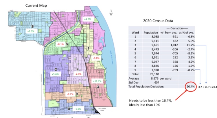
Evanston’s total population stood at 78,110, as of the 2020 Census, with an average size of 8,679 people for its nine wards.
Currently, there is a difference of 20.4% between the city’s most populous ward, the 3rd, along the lakefront, which is 1,012 people or 11.7% over the average, and the least populous, the 9th, at the city’s south end, with 759 people or 8.7% below the average.
Guided by the Equal Protection clause in the 14th amendment’s to the U.S. Constitution – “one person, one vote” – committee members since last year “have been very methodically looking at each ward individually and looking at the wards bordering in their effort to get ward population as close to even as possible,” said Council member Jonathan Nieuwsma, chair of the committee.
To that effort, Committee members established early on that they would preserve three wards as majority/minority— the Second, the Fifth and the Eighth.
The Fifth Ward, the object of the Committee’s discussion at their Jan. 26 meeting, is 705 people under the average, according to the 2020 Census figures.
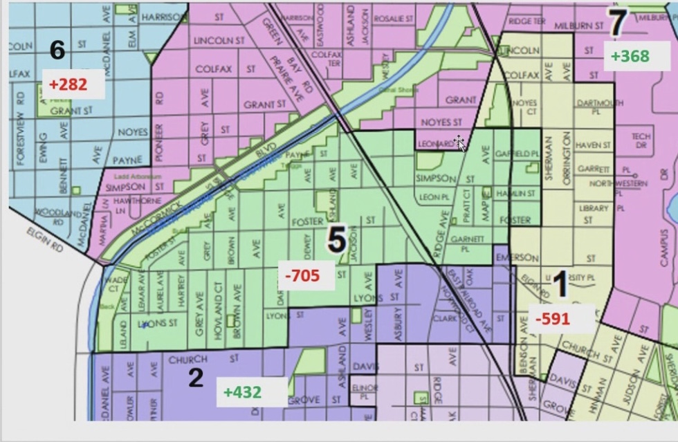
Meanwhile, the wards bordering it are the First Ward to the east, which is 591 people under the average, according to the 2020 Census figures. The Second Ward, just south, is 432 over, and Seventh Ward, to north and east, is 368 over.
With the completion of the ward-to-ward process, the Committee’s next steps is to start drafting several maps based on comments they received.
At the group’s March meeting, members of the public will have a chance to look at not just one final map, but two or three finalist maps, allowing Committee members to get additional input and coming up with a final recommendation to the Council.
Council approval, meanwhile, is scheduled for May. The final map would then go into effect starting with 2025 municipal election and will not apply to the special election in April of this year to fill two Council seats.