By Bob Seidenberg
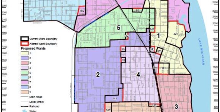
Members of the city’s Redistricting Committee have released a map proposing the first new political boundaries for the city in 20 years, using a light hand to keep ward lines as close to the present as possible.
Fourth Ward City Council member Jonathan Nieuwsma, chair of the committee, introduced the map at the April 10 Council meeting.
The proposed changes brought the deviation in population among the city’s nine wards down from 20.4% to 3.4%.
Ideally, a deviation of less than 10% is regarded as compliant with federal “one person, one vote,” standards.
In the new map, city’s Second Ward, with a population of 8,517, sits just 1.9% below average stands as the least populous, and the Fourth Ward the highest, with a population of 8,808 — but still at only 1.5% above the average.
At the start of the process, the committee grappled how to bring into balance a much wider gap.
Currently the least populous ward is the far south Ninth Ward, with 7,920 compared to 9,691 in the Third Ward in central and south Evanston, according to 2020 census figures.
“We talked about throwing the whole map out and starting with a blank sheet of paper,” Nieuwsma said. “But we decided to get as close as we can to equalizing populations through just a very light touch approach, which would impact as few as residents as possible.”
Committee members worked incrementally, devoting meetings to only a few wards.
“It’s a bit of a Tetris game —you can’t move one thing without moving to another,” Nieuwsma said about the challenge. “So it’s not quite as simple as ideally could have been. But what we’ve got here is a map that has a total population deviation of 3.4%.
The Committee – which included Council members Melissa Wynne, 3rd Ward; Nieuwsma; Bobby Burns, 5th Ward; and Devon Reid, 8th, Ward – also agreed to certain conditions early on.
The new map would maintain three majority non-white wards — the Second, the Fifth and the Eighth.
In addition, the downtown area would be split among wards, giving as many Council members as possible a voice in that area.
Officials estimated that 4,592 people would be impacted under the new map, that is, find themselves in new wards.
At the March 28 Committee meeting, several members of the 250-unit Sherman Plaza Condominium complex raised questions about the shift of that building from the First Ward to the Fourth Ward under the new configuration.
In the past, Sherman Plaza representatives have been strong voices on downtown issues at First Ward meetings.
One woman asked whether firefighters and police officers would be arriving from greater distances because of the change.
Nieuwsma assured the speaker that the change would not affect service.
Fred Tannenbaum, another downtown resident, though, noted that the Police Department “specifically has specific officers for downtown Evanston.”
Taking “us out of downtown Evanston, it will affect their beat,” he maintained. “That will change unless you want to talk to the police chief,” he said to the committee, speaking from a remote setup. “And make sure that the same officers that are in downtown will be taking care of the people on our block.”
During public comment at the April 10 City Council meeting, another speaker, Carl Klein, said that with one map as the sole focus, “You should allow for a full community outreach program to have comments on the ward map and you should have more than one ward map.”
He also spoke of the limited involvement in the drawing of the map.
At the Committee’s Feb. 28 meeting, maps proposed by Council member Nieuwsma and Third Ward Council member Melissa Wynne received the most interest as having the potential to move forward from members.
Council member Devon Reid, 8th Ward, had proposed a map that would extend his far south ward east, giving it a slice of the lakefront that now is in the Third Ward.
Just as committee members were conscious having “multiple wards and diverse wards representing downtown,” there is also a value “having multiple and diverse wards representing the lakefront,” Reid argued.
Further, the Eighth Ward would be the only majority-minority ward that would have some lakefront area if that move were made, he said.
Other committee members expressed concern, though, noting some alleys would have to be sliced through in drawing lines.
Wynne argued against the change, citing one of the guidelines committee members have adopted, “keeping communities of interest together.”
“I took my shot,” Reid said in that discussion.
At the April 10 City Council discussion, he said, “I proposed an alternative map; I gave up that battle. I still support somewhat of an alternative map. I think we’ll have more time on committee to have those discussions.”
Nieuwsma stressed that the map shown to the Council should be regarded as “a draft map, subject to additional comment.
“This is not the map we are proposing for formal approval tonight.”
He said the Committee — which held several town hearings last year, including one in Spanish— is set to meet April 25.At that meeting, he said, residents can give more feedback.
“We’ve allowed ourselves another month to take public input into account and do remapping that that we see fit.”
He said that the intent is to propose a final map for formal Council recommendation at the Committee’s May 23 meeting.Council would then approve the map “in June or thereabouts.”
Committee members purposefully did not want to rush through this process prior to the special election in April, feeling “it would have been really confusing to people,” Nieuwsma he said.
“But we wanted to get this done sooner rather than later.”
State law gives a deadline of mid-November of 2024 for the process to be completed, he said.